A massive superstorm has been ravaging southern parts of Western Australia and will continue to affect areas until this afternoon, according to the Bureau of Meteorology (BOM).
Described by a senior official at the Department of Fire and Emergency Services (DFES) as a “once-in-a-decade” storm, the weather event has left tens of thousands without power, uprooting trees, and even blowing roofs off houses, with winds of up to 100kph recorded around south-east suburbs of Perth.
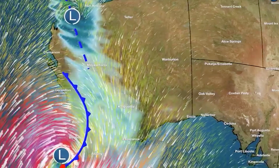
A rare storm has wreaked havoc in WA over the weekend and will continue to affect southern parts of the state until this afternoon, BOM reports.
BOM reported that the storm resulted from the remainder of tropical cyclone Mangga coinciding with a cold front. Up to 50,000 residents were left without power last night and crews were not able to attend to the outages due to the persisting dangerous weather.
“This is a rare event for Western Australia, particularly due to the extent of the area affected and the possibility of multiple areas of dangerous weather,” BOM described.
Prepare for an unusually widespread severe weather event along the west coast. Heavy rain and very gusty winds likely with dangerous surf and storm tides. By Sun night, severe weather will be confined to the SW of WA, easing during Mon. Latest warnings – https://t.co/X0UmpCmgQa pic.twitter.com/H8lTPQiTD7
— Bureau of Meteorology, Western Australia (@BOM_WA) May 23, 2020
Residents reported that the storm had even generated a massive dust storm which encased areas of Geraldton and Carnarvon yesterday afternoon.
WA storm whipping up a huge dust storm in Geraldton and Carnarvon. Pics posted to ABC Local Radio. @abcperth @abcnews @ABCemergency pic.twitter.com/obELmVbawU
— Gian De Poloni (@GianDePoloni) May 24, 2020
Eerie scenes in #Northampton, north of #Geraldton, as strong winds are whipping up large amounts of dust, blanketing large areas of the #CentralWest. Keep up to date with the latest Severe Weather Warning: https://t.co/WKZ9NekCiB
Video courtesy: Amery Drage. pic.twitter.com/DfZJA8xATq— Bureau of Meteorology, Western Australia (@BOM_WA) May 24, 2020
The storm has also generated abnormally high tides and surfers are currently being urged to avoid the beach.
Whilst the storm continues to impact some southern parts of the state, the weather is set to ease sometime this afternoon.
Damaging and local dangerous winds will gradually ease during the day over the SW of the State. Abnormally high tides may occur between Kalbarri and Augusta today. Damaging surf could occur between Denham and Israelite Bay. @dfes_wa @ABCemergency https://t.co/NikaX4QRKr pic.twitter.com/0LUr1M5R67
— Bureau of Meteorology, Western Australia (@BOM_WA) May 24, 2020
Elsewhere, a severe weather warning has been issued today for damaging surf in NSW, impacting areas of the Illawarra, Sydney Metropolitan, Hunter, and Mid North Coast districts with the conditions predicted to ease later this evening.
SEVERE WEATHER WARNING DAMAGING SURF: waves exceeding 5 metres in the surf zone, are likely for the Illawarra, Sydney Metropolitan, Hunter and Mid North Coast districts on Monday. Decreasing below 5 metres later Monday afternoon or evening.
Warning: https://t.co/25jwliUvcV pic.twitter.com/uJ4edoh1SF— Bureau of Meteorology, New South Wales (@BOM_NSW) May 24, 2020
In other news, BOM has predicted the country is in for a wet winter ahead.